


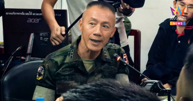
หลักฐานชัด! เปิดข้อมูล ความขัดแย้งชายแดนไทย-กัมพูชา มักเริ่มจากกัมพูชา
นักวิเคราะห์ข้อมูลดาวเทียมออสเตรเลีย เปิดหลักฐานชัด ความขัดแย้งชายแดนไทย-กัมพูชา ส่วนใหญ่จะเริ่มจากฝั่งกัมพูชา มีการเสริมกำลังหลายพื้นที่ก่อนการปะทะ
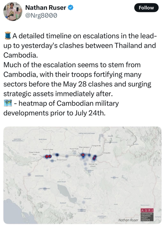
ทางเพจ The Wild Chronicles - ประวัติศาสตร์ ข่าวต่างประเทศ ท่องเที่ยวที่แปลก ได้เปิดหลักฐานชิ้นสำคัญที่ทำให้เห็นว่า การปะทะที่เกิดขึ้นนี้ เริ่มมาจากฝั่งกัมพูชา โดย คุณนาธาน รูเซอร์ ซึ่งเป็นผู้เชี่ยวชาญการวิเคราะห์ข้อมูลดาวเทียม ของ Australian Strategic Policy Institute หรือ ASPI บอกว่าเขานั่งไล่ดูข้อมูลแล้ว สถานการณ์ที่ถูกยกระดับส่วนใหญ่น่าจะเริ่มต้นจากฝั่งกัมพูชา โดยทหารของกัมพูชาได้เสริมกำลังในหลายพื้นที่ก่อนการปะทะเมื่อวันที่ 28 พ.ค. 2568 (ไม่ใช่รอบนี้นะครับ หมายถึง รอบเดือน พ.ค. ที่เป็นจุดเริ่มต้นของความขัดแย้งรอบนี้) และกัมพูชายังเร่งส่งทรัพยากรทางยุทธศาสตร์เพิ่มเติมทันทีหลังเหตุการณ์
ข่าวที่เกี่ยวข้อง

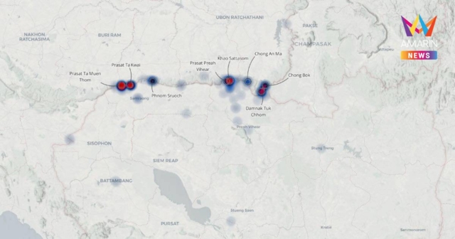
โดยเขาได้แนบแผนที่แสดงความหนาแน่นของกิจกรรมทางทหารของกัมพูชาก่อนวันที่ 24 ก.ค. 2568 มาด้วย
ซึ่งนักวิเคราะห์คนนี้ทำข่าวพื้นที่สงครามมาหลายจุด ทั้ง ยูเครน พม่า ค่อนข้างแม่นยำ ที่ผ่านมามีสื่อใหญ่นำข้อมูลของเขาไปใช้บ่อยครั้ง ข้อมูลดาวเทียมนี้เป็นของที่บิดผันไม่ได้ ขอให้ทุกท่านช่วยกันแชร์ออกไป เพื่อยืนยันแก่ชาวโลกว่าเกิดอะไรขึ้น
(เพจเดอะไวลด์โครนิเคิลส์) แปลอังกฤษไว้ให้ด้วยนะครับ
Mr. Nathan Ruser, a satellite imagery analyst at the Australian Strategic Policy Institute (ASPI), stated that after closely examining the data, most of the escalation appears to have originated from the Cambodian side. Cambodian troops reinforced several areas prior to the May 28 clashes (refer to the earlier event which marked the beginning of this current conflict). Cambodia also rapidly deployed additional strategic assets immediately following the incident.
He included a heatmap showing the concentration of Cambodian military activity prior to July 24.
Mr. Ruser has covered conflict zones in multiple regions - including Ukraine and Myanmar - and has built a reputation for accuracy. His findings are frequently cited by major international media outlets.
Satellite data of this nature is immutable. We urge everyone to share this widely, so the world can clearly see what has really taken place.
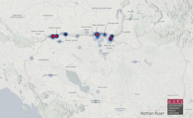
ภาพ : ASPI


Advertisement